
The 1973 event followed the basic pattern of the previous two years with a Sydney start (11 am at Hyde Park) then looping from Port Macquarie. The practice of the previous year of very long night stages was moderated with generally only one or two stages per night over 100 km. One short daylight stage was contested on the first afternoon while the final three stages on the last morning were in daylight. Five stages marked below as "special" were timed to the quarter minute.
The distances and number of stages was as follows:
| Special Stages | Special Stage | Transport | Total | Competitive | Longest Stage | |
| Day One | 10 | 450.90 km | 426.95 km | 877.85 km | 51.4% | 124.95 km |
| Day Two | 10 | 412.70 km | 390.35 km | 803.05 km | 51.4% | 88.55 km |
| Day Three | 7 | 458.95 km | 218.40 km | 677.35 km | 67.8% | 141.40 km |
| Day Four | 13 | 500.15 km | 387.30 km | 887.45 km | 56.4% | 101.65 km |
| Event | 40 | 1822.70 km | 1423.00 km | 3245.70 km | 56.2% | 141.40 km |
Further details are provided below for each day. Competitive section denoted "Special" were timed to the quarter minute.
Day One

Click the map to go to a Google Maps trace of the route. |
The long transport sections out of Sydney were interrupted by a short daylight stage at Hawkmount south-west of Newcastle. The competition began in earnest with two stages of almost 60 km each through the Myall and Wang Wauk forests before a service at Wooton on the (Old) Pacific Highway. A short stage east of the highway through the Bachelor forest was followed by a stage that began in the north end of the Wang Wauk forest then used shire roads generally northwards to the Bucketts Way east of Gloucester. The final stage before the mealbreak in Taree was a 27 km run through the Kiwarrak Forest. After Taree the crews headed out to Mount George for a virtual loop stage of 125 km through the Dingo Tops, returning down the super fast Nowendoc Road. A quick run along Black Flat Lane preceded a refuel back in Wingham. Another short stage through the Yarrat Forest was soon followed by the night's final stage of 90 km through the Kerewong, Lorne and Broken Bago forests, including the infamous Rollover Road. |
Stage details
Click on the special stage name to see the map.
| Stage | Name | SS Distance | Transport Distance | Time Allowed | First Car |
| 1 | Tollway Transport (Reptile Park, North Gosford) | 83.60 km | 120 mins | 1.00 pm | |
| 2 | Wyong (Showgrounds) Transport | 43.40 km | 50 mins | 1.52 pm | |
| 3 | Dora Creel Transport | 8.55 km | 10 mins | 2.04 pm | |
| 4 | Hawkmount Special | 9.00 km | 7 mins | 2.13 pm | |
| 5 | Wallsend Transport (Jesmond Shopping Centre) | 24.80 km | 40 mins | 2.55 pm Depart 3.30 pm |
|
| 6 | Raymond Terrace Transport | 75.70 km | 90 mins | 5.00 pm | |
| 7 | Cabbage Tree | 58.60 km | 46 mins | 5.48 pm | |
| 8 | Bulahdelah Transport | 17.40 km | 20 mins | 6.10 pm | |
| 9 | Possum Pie | 57.20 km | 45 mins | 6.57 pm | |
| 10 | Wootton Transport | 6.75 km | 15 mins | 7.14 pm | |
| 11 | Kennedy's Gap | 14.45 km | 12 mins | 7.28 pm | |
| 12 | Coolongolook Transport | 15.60 km | 15 mins | 7.45 pm | |
| 13 | Tipperary | 46.50 km | 37 mins | 8.24 pm | |
| 14 | Nabiac Trasport | 39.15 km | 35 mins | 9.01 pm | |
| 15 | Breakneck | 27.00 km | 21 mins | 9.24 pm | |
| 16 | Taree Transport (CNCSCC Rooms) | 14.15 km | 30 mins | 9.56 pm Depart 10.36 pm |
|
| 17 | Mount George Transport | 31.85 km | 30 mins | 11.06 pm | |
| 18 | Number One | 124.95 km | 96 mins | 12.42 am | |
| 19 | Nowendoc Road Transport | 2.35 km | 3 mins | 12.47 am | |
| 20 | Black Flat Lane | 10.50 km | 8 mins | 12.57 am | |
| 21 | Wingham Transport | 22.05 km | 30 mins | 1.29 am | |
| 22 | Yarrat | 12.70 km | 10 mins | 1.41 am | |
| 23 | Upper Lansdowne Transport | 13.20 km | 15 mins | 1.58 am | |
| 24 | Koppin Yarrat | 90.00 km | 70 mins | 3.10 am | |
| 23 | Wauchope Transport | 28.40 km | 45 mins | 3.57 am |
Route instructions are available here.
Day Two
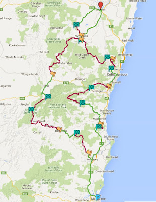
Click the map to go to a Google Maps trace of the route. |
Day 2 began with a fairly straightforward run through the Collombatti Forest before a lengthy run along the main Kempsey to Armidale Road, which is a big gravel road with both fast and tight sections. A short run through the Styx Forest was made famous by the demise of Tony Fall at what was subsequently known as Tony Fall's bridge! After a service near Ebor crews tackled a challenging stage through the little used Hyland and Chaelundi Forests to Nymboida. A short run up Glen Creek Road preceded the refuel and mealbreak in Grafton. Heading south again crews headed down Black Mountain Road and into the area made famous by the WRC Shipmans stage before emerging at Nana Glen. A tricky stage through the Bucca Forest was followed by a refuel in Coffs Harbour. The next stage headed through the Pine Creek and Tuckers Knob Forests to the Gordonville ford, which was used competitively despite the wet weather. A lengthy stage followed immediately, using the northern half of Horseshoe Road then down Bellbucca Road to Missabotti. The division's final stage was a short special (timed to the quarter minute) through Way Way Forest before the lengthy transport back to Port. |
Stage details
Click on the special stage name to see the map. Estimated times are a guess.
| Stage | Name | SS Distance | Transport Distance | Time Allowed | First Car |
| 1 | Telegraph Point Transport | 59.35 km | 75 mins | 5.45 pm | |
| 2 | Collombatti | 38.10 km | 30 mins | 6.17 pm | |
| 3 | Millbank Transport | 27.50 km | 25 mins | 6.44 pm | |
| 4 | The Big Hill | 67.00 km | 52 mins | 7.38 pm | |
| 5 | Styx River | 25.60 km | 20 mins | 8.00 pm | |
| 6 | Ebor Transport | 36.00 km | 40 mins | 8.42 pm | |
| 7 | Chaelundi | 88.55 km | 75 mins | 9.59 pm | |
| 8 | Nymboyda Transport | 5.35 km | 8 mins | 10.09 pm | |
| 9 | Glens Crossing | 15.30 km | 12 mins | 10.23 pm | |
| 10 | Obx Creek Transport (South Grafton) | 38.10 km | 35 mins | 11.00 pm Depart 11.30 pm |
|
| 11 | Coutts Crossing Transport | 43.95 km | 45 mins | 12.15 am | |
| 12 | Coldwater Creek | 52.95 km | 42 mins | 12.59 am | |
| 13 | Nana Glen Transport | 7.70 km | 10 mins | 1.11 am | |
| 14 | Bucca | 24.50 km | 19 mins | 1.32 am | |
| 15 | Coffs Harbour Transport | 28.65 km | 50 mins | 2.24 am | |
| 16 | Gordonville Ford | 29.60 km | 23 mins | 2.49 am | |
| 17 | Horseshoe | 58.40 km | 46 mins | 3.37 am | |
| 18 | Missabotti Transport | 44.00 km | 45 mins | 4.24 am | |
| 19 | Yarrahapinni Special | 12.70 km | 10 mins | 4.36 am | |
| 20 | Telegraph Point Transport | 99.75 km | 100 mins | 6.18 am |
Route instructions are available here.
Day Three

Click the map to go to a Google Maps trace of the route. |
The third night began with a quick run through Cairncross. Next up was a 50 km run up through the Ballengarra and Kalateenee Forests to a refuel at Kempsey. A fairly straightfoward run up through Tan Ban and Ingalba Forests took crews to Utungan and service at Bowraville. The night's longest stage, and the event's, was a 141 km run up the southern half of Horseshoe Road, down the treacherous Boulder Road into the Taylors Arm valley, a loop north-west into the Thumb Creek Forest and a final run down into the Collombatti Forest using much of the previous night's first stage in reverse. After another refuel in Kempsey came another long stage, this time 115 km through the Kippara and Bellanry Forests ending down on Hastings Forest Way. A transport through Wauchope took crews backclose to Port for the start of another long stage which began in the Cowarra Forest, then meandered through the Bago, Bulls Ground, Kerewong and Lorne Forests all the way to Comboyne. A short transport through the village took crews to the final stage of the night along the treacherous and twisty Toms Creek Road. A lengthy transport down the Oxley Highway took crews back to Port for a well earned rest. |
Stage details
Click on the special stage name to see the map. Estimated times are a guess.
| Stage | Name | SS Distance | Transport Distance | Time Allowed | First Car |
| 1 | Hibbard Transport | 23.85 km | 30 mins | 5.30 pm | |
| 2 | Cairncross Special | 23.65 km | 19 mins | 5.51 pm | |
| 3 | Ballengarra Transport | 7.90 km | 7 mins | 6.00 pm | |
| 4 | Kalateenee | 51.00 km | 40 mins | 6.42 pm | |
| 5 | Frederickton Transport | 23.20 km | 40 mins | 7.24 pm | |
| 6 | Tan Ban | 33.75 km | 27 mins | 7.53 pm | |
| 7 | Congarinni Transport | 26.30 km | 35 mins | 8.30 pm | |
| 8 | Doug's Drop | 141.40 km | 115 mins | 10.27 pm | |
| 9 | Greenhill Transport | 23.10 km | 25 mins | 10.54 pm Depart 11.34 pm |
|
| 10 | Burnt Bridge Transport | 4.35 km | 8 mins | 11.44 pm | |
| 11 | Tuckybunyabah | 115.20 km | 90 mins | 1.16 am | |
| 12 | Beechwood Transport | 31.40 km | 40 mins | 1.58 am | |
| 13 | Kerewong | 80.60 km | 63 mins | 3.03 am | |
| 14 | Comboyne Transport | 6.40 km | 7 mins | 3.12 am | |
| 15 | Toms Creek | 13.35 km | 11 mins | 3.25 am | |
| 16 | Long Flat Transport | 71.90 km | 75 mins | 4.40 am |
Route instructions are available here.
Day Four
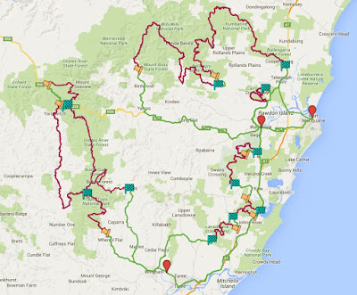
Click the map to go to a Google Maps trace of the route. |
The final night began with a lengthy transport out to north of Yarras. Two lengthy stages of 78 km and 102 km followed through the Mount Boss, Bellangry and Kippara Forests, interrupted by a service at Bellangry. Crews then transported through a mealbreak at Wauchope to the Bago Forest for a series of relatively short stages through the Bulls Ground, Middle Brother and Lansdowne Forests. Another lengthy transport took in a refuel in Wingham then up to Wherrol Flat for a series of stages in the Dingo Tops and beyond. Two stages of 32 km and 45 km lead to a service on the Oxley Highway near Myrtle Scrub. The 26 km stage north of the highway may have been shortened due to the conditions. A treacherous 63 km stage followed down Eaglehawk Trail and onto Cells Road before climbing back up to the earlier control on Dingo Tops. A further 34 km stage out to Elands effectively ended the night's competition before crews headed to the CNCSCC Club Rooms near Taree for breakfast. Three daylight stages remained, in Middle Brother, the infamous Rollover Road and an exact repeat of the Day 3 run through Cairncross, before the finish back at Port. |
Stage details
Click on the special stage name to see the map. Estimated times are a guess.
| Stage | Name | SS Distance | Transport Distance | Time Allowed | First Car |
| 1 | Yarras Transport | 84.15 km | 90 mins | 6.00 pm | |
| 2 | Cockerawombeeba | 78.20 km | 61 mins | 7.03 pm | |
| 3 | Bellangry Transport | 8.50 km | 18 mins | 7.23 pm | |
| 4 | Cobrabald | 101.65 km | 80 mins | 8.25 pm | |
| 5 | Pembroke Transport | 29.35 km | 40 mins | 9.07 pm Depart 9.47 pm |
|
| 6 | Bago Road Transport | 8.80 km | 10 mins | 9.57 pm | |
| 7 | Lorne | 26.60 km | 21 mins | 10.20 pm | |
| 8 | Kendall Transport | 11.35 km | 10 mins | 10.32 pm | |
| 9 | Bird Tree | 15.45 km | 12 mins | 10.46 pm | |
| 10 | Stewarts River Transport | 4.85 km | 5 mins | 10.53 pm | |
| 11 | Vincents Lookout | 20.60 km | 16 mins | 11.15 pm | |
| 12 | Lansdowne Transport | 54.45 km | 60 mins | 12.17 am | |
| 13 | Dingo Tops | 31.40 km | 25 mins | 12.44 am | |
| 14 | Doyles River | 44.90 km | 35 mins | 1.21 am | |
| 15 | Myrtle Scrub Transport | 12.65 km | 20 mins | 1.43 am | |
| 16 | Seaview | 25.70 km | 20 mins | 2.05 am | |
| 17 | Tobins Camp Transport | 4.90 km | 7 mins | 2.14 am | |
| 18 | Strike-a-Light | 62.55 km | 50 mins | 3.06 am | |
| 19 | Bulga Plateau | 34.35 km | 27 mins | 3.35 am | |
| 20 | Elands Transport | 44.10 km | 60 mins | 4.37 am Depart 6.30 am |
|
| 21 | Moorland Transport | 45.90 km | 67 mins | 7.37 am | |
| 22 | Middle Brother Special | 15.10 km | 12 mins | 7.51 am | |
| 23 | Kew Transport | 26.15 km | 40 mins | 8.32 am | |
| 24 | Rollover Special | 20.00 km | 15 mins | 8.49 am | |
| 25 | Wauchope Transport | 28.25 km | 45 mins | 9.36 am | |
| 26 | Cairncross Special | 23.65 km | 18 mins | 9.56 am | |
| 27 | Port Macquarie Transport | 23.90 km | 30 mins | 10.30 am |
Route instructions are available here.